Corral del Veleta Glacier: Europe's Southernmost Ice
Corral del Veleta held Europe's southernmost glacier — active until 1913 at 37°N. Relict ice and permafrost still cling on in Sierra Nevada, shrinking fast.
Seven years resident in Granada. Specialist in Nasrid architecture, Al-Andalus history, and Andalusian walking routes.
Updated Published
At 37 degrees north, in a north-facing cirque below Veleta's 3,398-metre summit, Europe's most southerly glacier survived until 1913; a rocky glacial remnant still clings on today.[1] Climate warming of close to 1°C since the late 20th century, combined with shrinking snowfall, has the remaining ice degrading faster every decade.[2] If the phrase "visit while you can" is overused, here it is earned.
In this article
Jump to a section
⌄
Formation and geography: a cirque built for ice
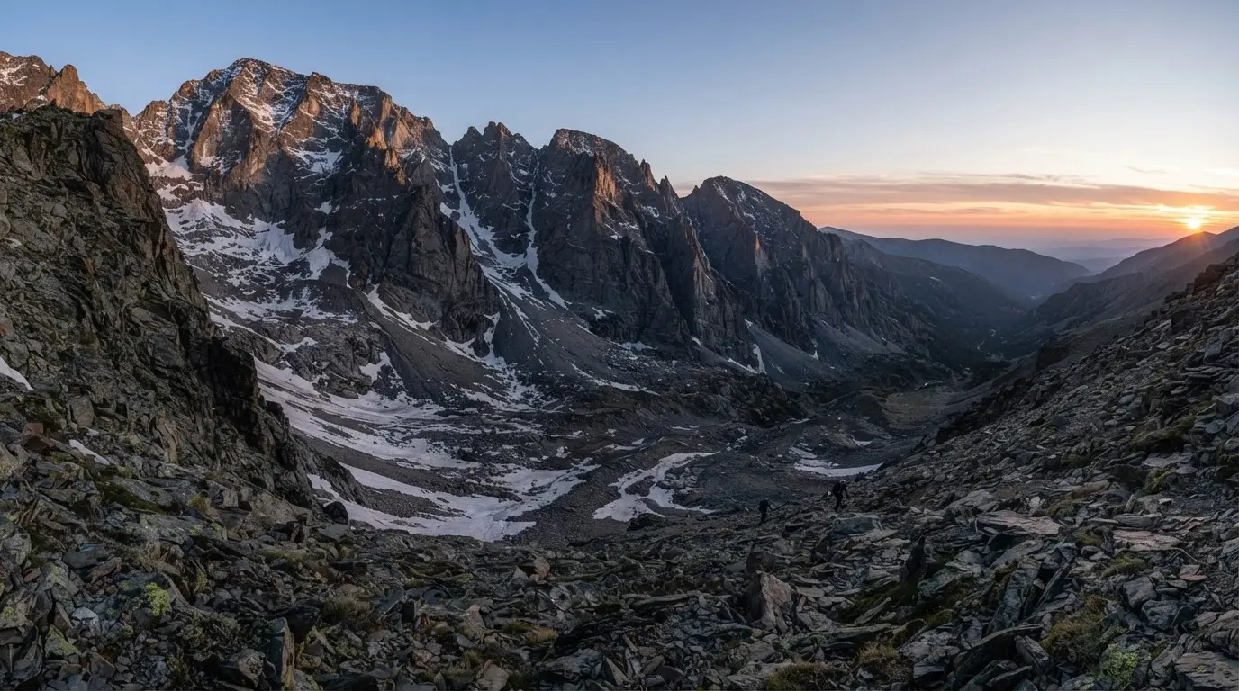
Veleta stands at 3,398 metres, the second-highest peak in the Sierra Nevada and third-highest point in the Iberian Peninsula (behind Mulhacén at 3,479 m and Aneto in the Pyrenees at 3,404 m).[1] The summit sits near the park boundary of the Sierra Nevada National Park, which covers 86,208 hectares of mountain terrain.[5] A lower flank of the same peak, at 2,850 metres, carries a working Pico Veleta telescope rather than ice — the IRAM radio observatory that helped capture the first-ever image of a black hole. But the summit itself is not where the glacier story takes place. Drop north from the peak and you fall into the Veleta cirque: a north-facing bowl with walls exceeding 300 metres in height, carved over millennia by ice that ground against the rock face, plucking and dragging material downslope.
The cirque's orientation is everything. South-facing slopes in Sierra Nevada bake through long Andalusian summers. The north-facing Veleta bowl stays in shadow for the better part of each day, intercepting wind-blown snow from storms crossing from the Atlantic and holding it through seasons that would melt any exposure elsewhere. This geometry, not altitude alone, is why ice persisted here at a latitude where most mountains carry none.
The Quaternary glaciation reached its maximum extent in the Iberian Peninsula roughly 20,000 years ago.[3] At the Veleta cirque, a full valley glacier descended northward from the summit ridge, excavating the bowl and depositing moraines that still define the valley floor.[6] Final deglaciation came around 15,000–14,000 years ago (15–14 ka), as global temperatures climbed out of the last glacial maximum.[6] What the Quaternary left behind was not just a landscape but the preconditions for everything that followed: a deep, shaded hollow with the geometry to hold snow and eventually rebuild ice during cooler periods.
The valley below the cirque connects directly to the Granada metropolitan area. Meltwater from the Veleta and surrounding high-altitude terrain drains into the river systems that supply both Granada and Almería provinces with fresh water, a connection between mountain ice and lowland cities that has become harder to ignore as the ice shrinks.[2]
Permafrost has been detected in the cirque at 3,150 metres elevation, another signature of the cold microclimate that the north-facing walls have sustained for centuries.[3] This is periglacial territory: the zone between permanent ice and ordinary mountain terrain, producing landforms found almost nowhere else in southern Europe at this latitude.
The same Sierra Nevada belongs to the Betic ranges that shape Granada's earthquakes.
The southernmost glacier: Little Ice Age peak and the 1913 line
Between the 14th and 19th centuries, a cool period known as the Little Ice Age dropped mean temperatures across Europe sufficiently to rebuild glaciers in high mountain environments. In the Sierra Nevada, two cirques responded: Veleta and its smaller neighbour. Together they held the southernmost glaciers in Europe, a distinction that held from the Little Ice Age peak through into the early 20th century.[1]
The active glacier in the Veleta cirque survived as a functioning ice body until 1913, when glaciologists formally recorded its transition from active glacier to stagnant or relict ice.[1] An active glacier moves: it flows under its own weight, advances in accumulation years, retreats in ablation years, creeps against bedrock. When movement stops, the body becomes a glacial remnant: still ice, still relevant, but no longer a glacier in the full glaciological sense.
Glaciers at extreme latitudinal margins respond to climate signals more dramatically than those embedded in large ice fields. There is no thermal mass to buffer individual bad winters or dry summers. The Veleta ice survived precisely because of the cirque geometry, not because the climate could support it more broadly. This made it both a record-setter and an outlier: southernmost in Europe but also fragile in a way that continental glaciers are not.
The significance of 37°N as the glacier's coordinate is not merely statistical. Most European glacier research has focused on the Alps, the Pyrenees, and Scandinavia, mountain ranges where ice exists in abundance and retreat, while alarming, happens across hundreds of kilometres of terrain. The Veleta case is the edge case: a single surviving ice body at a latitude where glaciers have no business existing, keeping that existence through a precise combination of altitude, shade, and cold-air pooling that the surrounding lowlands cannot replicate.
What remains today: relict ice, permafrost, and a shrinking body
A survey conducted in 2008 measured what the Veleta cirque still holds: a rocky glacier body approximately 129 metres long, 8 metres thick, covering 4,860 m² at an elevation of roughly 3,106 metres.[3] These figures describe not a glacier in the classical sense but a rock glacier: a mixture of ice, rock debris, and sediment that moves far more slowly than clean ice and responds to temperature changes across longer timescales.
The ice inside this body is composite. Researchers have identified three components: fossil ice (very old ice from the Little Ice Age that has not melted but also no longer moves), relict ice (transition-era ice undergoing active degradation), and permafrost (ground ice frozen into the surrounding rock and sediment).[3] This is not a coherent mass that will melt cleanly on a warm summer afternoon; it is a complex layered structure that degrades from within as well as from the surface.
4,860 m²
Measurements taken in 2008 for the remaining rocky glacier body in the Veleta cirque: 129 metres in length, 8 metres thick, covering just under 4,860 square metres. It contains fossil ice, relict ice, and permafrost, all three components in active degradation.[3]
Post-2014 surveys documented structural deterioration with internal partitioning developing inside the ice body. In effect, the glacier began fracturing into compartments as the cohesive bonds between sections weakened.[3] Once an ice body begins fragmenting this way, overall ablation accelerates: more surface area is exposed to solar radiation and warm air, and the thermal insulation provided by the rock debris above becomes less effective as structural integrity drops.
Recommended tours
Tours are selected for quality, not commission. We earn a small fee if you book — at no extra cost to you.
The 4,860 m² figure from 2008 represents a body roughly the size of a single football pitch.[1] For context: at the Little Ice Age peak, the Veleta glacier covered considerably more ground; the moraines in the valley below mark its maximum extent. What 2008 measured was already late-stage survival, not a remnant in good health.
Climate change and the retreat data
The numbers from the Veleta cirque track what is happening to mountain ice across southern Europe, but in a compressed, legible form. Between 1995 and 1999, ablation (ice loss) ran at 1–5 centimetres per year, detectable but gradual.[1] Between 2001 and 2007, the ice body displaced 75 centimetres in total across the six-year period.[1] From 1998 to 2009, the glacier lost 10 metres of thickness.[1] Eleven years to shed ten metres of vertical ice is the kind of figure that makes the 2008 survey's 8-metre total thickness seem precarious.
Temperature records from Sierra Nevada show warming of close to 1°C since the late 20th century, alongside measurable reductions in snowfall.[2] The warming figure sounds modest until you apply it to an ice body already at its survival threshold. A continental glacier might absorb a degree of warming through its accumulated cold mass; the Veleta remnant has no such reserve.
The year-to-year dynamics reveal how thin the margin is. Dry years like 2003 and 2005 produced dramatic ablation: the ice lost ground fast with no winter accumulation to replace what summer removed.[1]Consecutive snowy winters reversed the trend temporarily: the ice showed minimal net loss in years when deep snowpack built up early and lasted late.[1] The glacier is not in free fall; it oscillates. But the long-term direction of that oscillation is one way.
Structural changes accelerated after 2014 with the development of internal partitioning.[3] When an ice body begins fragmenting internally, each separate compartment becomes more vulnerable than the whole was. The insulating rock debris on top of a rock glacier works because it covers a continuous mass; when that mass develops cracks and gaps, warm air and radiation reach previously insulated zones.
Sierra Nevada holds the distinction of being the first mountain range in Europe to lose all its modern glaciers during the 20th century.[2] The Veleta remnant is not a replacement glacier. It is the last fragment of something much larger, surviving in a single shaded cirque because the geometry there is marginally better than everywhere else on the range.
Ecological and water significance
The Sierra Nevada National Park's 74 documented glacial lagoons are the most visible legacy of the Quaternary glaciation.[5] These high-altitude lakes, some permanent, others seasonal, sit in basins carved by ice that is long gone. They support plant communities and invertebrate populations found nowhere else in Andalusia, species that evolved in cold, nutrient-poor water and have no alternative habitat within hundreds of kilometres.
Meltwater from the high Sierra Nevada feeds the river systems supplying Granada and Almería provinces directly.[2] The seasonal melt cycle from persistent snow and ice bodies in the upper cirques acts as a buffer: winter snow stores precipitation, summer melt releases it slowly through the driest months. As the permanent ice bodies shrink and snowpack patterns shift, this buffering function weakens. The provinces downstream will feel the change in their water availability before they see it in any survey of the mountains above. This matters most in Granada in summer, when river levels drop and urban water demand peaks.
Permafrost at 3,150 metres in the Veleta cirque also holds water, not as liquid but as ice locked into rock fissures and sediment.[3] When permafrost thaws, it releases this stored water in pulses, but it also destabilises slopes. The geomorphological consequences of permafrost loss in high mountain environments include rockfalls and debris flows, hazards that change the character of terrain that generations of hikers and researchers have walked without incident.
Timeline
~20,000 years ago
Quaternary glacial maximum
A full valley glacier descends from the Veleta summit ridge, carving the cirque and depositing moraines on the valley floor below.
~15,000–14,000 years ago
Final deglaciation
Global temperatures rise out of the last glacial maximum. The Veleta valley glacier retreats and disappears. The cirque bowl it carved remains.
14th–19th century
Little Ice Age
Cooler temperatures rebuild ice in two Sierra Nevada cirques. The Veleta glacier becomes the southernmost active glacier in Europe, at 37°N.
1913
Active glacier ends
The Veleta glacier loses all measurable movement. It transitions from active glacier to glacial remnant. Sierra Nevada becomes the first European mountain range to lose all modern glaciers.
1998–2009
10 metres of thickness lost
Systematic monitoring records 10 metres of vertical ice loss over eleven years. Internal partitioning develops after 2014.
2008
Survey: 4,860 m² remaining
The rocky glacier body measures 129 metres long, 8 metres thick, 4,860 m², containing fossil ice, relict ice, and permafrost at 3,106 metres elevation.
The research value of the Veleta remnant extends beyond its size. Because it sits at the absolute southern margin of European glaciology,[4] it functions as an early-warning site: a place where climate signals that will eventually affect larger ice bodies appear first, in their most concentrated form. Studies here have fed into broader European models for periglacial relict landforms and their rate of degradation under projected warming scenarios.
Visiting the Corral del Veleta
The Veleta cirque is accessible from Granada via the A-395 mountain road that climbs through the Sierra Nevada ski resort area to the Borreguiles plateau. From the ski resort base at Pradollano (2,100 m),[1] the road continues higher in summer, typically opening in June and closing with first heavy snowfall in October or November. The Pico del Veleta car park sits near 3,300 metres, one of the highest drivable points in Europe,[1] and from there the cirque drops away to the north on foot.
The descent into the cirque is not a formal trail. The terrain is rocky scree and moraine debris with no path markers; a map and basic mountain experience are required. Allow at least three hours for the round trip from the car park, more if conditions are wet or snowy. The cirque floor sits at around 3,100 metres.[1] Altitude effects are real at this elevation even for acclimatised visitors: headaches and shortness of breath are common above 3,000 metres[5] if you drive rather than hike up.
Best season: July through September gives the longest snow-free window and the clearest views of the glacial remnant. August is also when melt is most active and water flow in the moraine channels most visible. July evenings cool fast: temperatures drop below 5°C after sunset at 3,000 metres,[5] so layers are essential regardless of the daytime forecast in Granada city. That same elevation effect, only far less extreme, is why Granada city itself runs colder than the rest of Andalusia every winter.
The Sierra Nevada National Park requires no entry permit for day walking. The park visitor centre at Pampaneira (in the Alpujarras) has information on conditions and temporary closures; the park authority also posts road status for the A-395 at the start of each summer season. Guided geological tours of the cirque area run from the ski resort base in July and August, a useful option for anyone who wants the scientific context explained on the ground.
For the glacial remnant specifically: it lies below and north of the car park, in the shaded hollow that gives the cirque its distinctive dark aspect in afternoon light. On clear days in July, the contrast between the sun-bleached summit rocks above and the shadowed floor of the cirque below is visually stark. The ice, if visible at all, will show as grey-brown hummocks covered in debris. Not the blue-white of a photogenic alpine glacier, but something quieter and more ambiguous.
Granada city is 27 kilometres from the ski resort base by road. The Granada outdoor adventures guide covers additional high-mountain routes and seasonal access logistics for the national park. Come back after dark in summer and the same access road serves an entirely different purpose: our guide to stargazing near Granada covers where the guided night-sky programmes actually run, well below this cirque but on the same mountain.
Frequently asked questions
Is the Corral del Veleta glacier still active?
No. The Veleta glacier lost all measurable movement in 1913, transitioning from an active glacier to a glacial remnant. What remains today is a rocky glacier body (a mixture of fossil ice, relict ice, and permafrost) that is actively degrading but no longer moves as a functioning glacier.
Why is Corral del Veleta called the southernmost glacier in Europe?
During the Little Ice Age (14th–19th centuries), the Veleta cirque held an active glacier at 37°N latitude, further south than any other in Europe. The north-facing cirque walls create a shaded microclimate that allowed ice to persist at a latitude where no other European mountain sustained a glacier. Sierra Nevada was the first European mountain range to lose all its modern glaciers during the 20th century.
When did the Veleta glacier disappear?
The active glacier ceased all movement in 1913. A glacial remnant (rocky glacier with relict ice and permafrost) still exists today, but it is not a functioning glacier. The remnant measured 4,860 m² in 2008, with 10 metres of thickness lost between 1998 and 2009.
How fast is the glacier retreating?
Retreat has accelerated over time. Between 1995 and 1999, ablation ran at 1–5 cm/year. Between 2001 and 2007, total displacement reached 75 cm across six years. From 1998 to 2009, the ice lost 10 metres of thickness. Dry years like 2003 and 2005 caused sharp losses; consecutive snowy winters have shown temporary stabilisation. Sierra Nevada warming of close to 1°C since the late 20th century is the underlying driver.
Can you visit the Corral del Veleta glacier?
Yes. The A-395 mountain road reaches the Veleta car park at around 3,300 metres, typically open from June to October. From the car park, the cirque is accessible on foot across rocky scree; allow three hours for the round trip. No entry permit is required for the Sierra Nevada National Park. The best window is July through September. Basic mountain experience and warm layers are essential even in summer.
What elevation is the Corral del Veleta?
Veleta peak stands at 3,398 metres. The cirque floor and glacial remnant sit at approximately 3,106 metres elevation. The north-facing walls of the cirque exceed 300 metres in height. Permafrost has been detected at 3,150 metres within the cirque.
How does glacier melt affect Granada's water supply?
Meltwater from the Sierra Nevada high zone directly sustains water resources for Granada and Almería provinces. Persistent snow and ice bodies act as a seasonal buffer, storing winter precipitation and releasing it slowly through the driest summer months. As the ice bodies shrink, this buffering function weakens, reducing the reliability of summer water flow into the river systems supplying both provinces.